climate
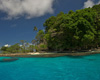
Located at the eastern extremity of the Western Province of the Solomon Islands at 8° 47.304´S 158° 13.937´E The Wilderness Lodge lies at the northern fringe of the South Pacific tradewind belt, with a warm to very warm tropical climate with moderate rainfall and plenty of sunshine. For more details read on......
general
The June through October tradewind season is typified by 22 - 26°C nights and 26 - 29°C days, cool seabreezes most days with lower humidity. Winds typically peak at 12 - 20 knots in the early afternoon and ease and locally swing offshore at night. When large high-pressure systems pass across the Tasman Sea during this time of the year, the tradewinds occasionally reach 25 knots.
The Christmas through April northwest monsoon season sees temperatures rise a couple of degrees and humidity increase, calm weather interspersed with squally periods, though the lodge is protected from much of this weather by Mt Mariu.
Tropical depressions form in the Solomons region, embedded in the ITCZ/SPCZ (see below for explanation) between December and May, occasionally becoming cyclones as they travel to the southeast towards Vanuatu and Fiji, or southwest towards Australia. Cyclones in the main Solomons chain are rare, with no record of a tropical cyclone having crossed Gatokae. We are fortunate enough, however, to receive beautiful groundswell surf from these distant storms on rare occasions.
2900 foot Mt Mariu generates a light, cool nightly land breeze (being most apparent in the very early morning) for much of the year which makes the warm nights comfortable.
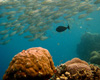
Ocean temperature ranges from 26.5°C when tradewinds push cooler water up from further south and also stir colder subsurface water to the surface. The warmer monsoon season sees ambient water temperatures rise to 31°C. The equatorial sun heats the shallower Peava lagoon during the day to around 34°C and the reef pools as high as 40°C during the mid year spring low tides.
From an activity perspective, the mid-June through October tradewinds and the December-March monsoon can at times make boating wet, however many of the fishing grounds and dive sites around the offshore islands are accessible in all weather. Trips to Kavachi and the oceanic seamounts and FADs (10 - 20 nautical miles offshore) are less frequent during the mid-June through October tradewind season. Walking and hiking are just as rewarding on cool wet days, refer to the 'what to bring' page to ensure you have the right gear to really enjoy it.
Being situated on the beach and specifically designed to remain cool and comfortable year-round, the Lodge is a great base for exploring the rich surrounding nature.
rainfall
Our most significant rainfall generally falls during the heart of the tradewind season July through September, generated by moisture picked up as the tradewinds blow thousands of miles across the South Pacific Ocean and falling as it strikes land and the 2900 foot peak of Gatokae. The Christmas through April northwesterly monsoon also produces precipitation, though this is tempered by the fact that Wilderness lies on the southeast (leeward, at that time of the year) side of the New Georgia Group.
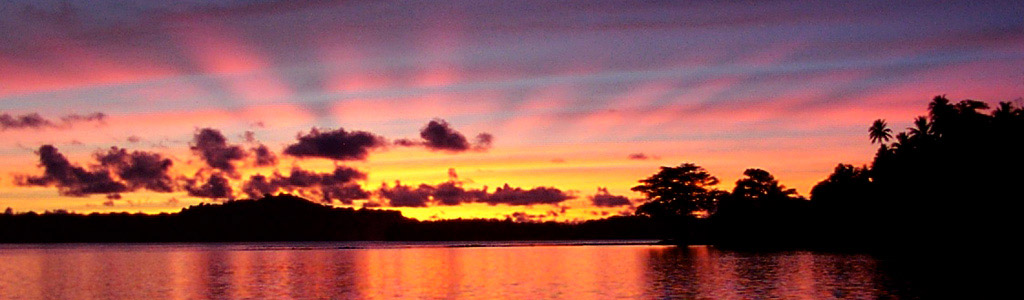
The dense lush tropical rainforest that cloaks Gatokae also transpires a considerable amount of moisture back into the atmosphere as clouds which can produce brief, intense downpours as they move across the interior of the island, thus it is good practice to carry a snaplock bag or such for your camera and anything else not waterproof when you're out and about. Watching this process of instant cloud formation by the forest and by the tradewinds over the steep volcanic peak, and the interplay of equatorial sunlight, is a wondrous and meditative experience.
climatic factors & patterns
Two primary factors control our weather. The first is the equatorial convergence zone - a combination of the Inter-Tropical Convergence Zone (ITCZ) that occurs within approx 15 degrees of the equator as a result of the Northern Hemisphere northeasterly tradewinds and the Southern Hemisphere southeasterly tradewinds meeting at the equator; along with a localised counterpart the South Pacific Convergence Zone (SPCZ) which typically lies in a northwest-to-southeast line just to the northeast of the Solomons, over the pool of very warm equatorial ocean that also controls the El Nino/La Nina Effects. These convergence zones are bands of low pressure and cloud that shift unpredictably across the equatorial Pacific through the year.
The second primary controlling factor is a phenomenon termed Hadley Cells that move air from approx 30 degrees south latitude back to the equator, this airflow is turned in a northwesterly direction by the Coriolis Effect (simply the effect of the Earth's rotation from west to east) producing the Southeast Tradewinds (or 'The Trades' as they're affectionately known in the Pacific Islands)
Thus the primary pattern in our weather is the shift between influence of the Hadley Cells - typically producing southeast tradewinds from June through October; and influence of the convergence zones - typically producing predominately northwest 'monsoon' winds from around Christmas to mid-April.
The interim periods of April through June and October through Christmas represent transition between these two influences, and are typically our finest and calmest times of the year. Our proximity to the equator (8 degrees south) however, means the ITCZ/SPCZ can move down over us at any time of year, making forecasting a task that gives even the Cray supercomputers at NOAA a headache, and epitomising the lack of knowledge humans possess of the global engine of ocean currents that controls the weather.